


-
MIA011: Disc-Shaped Feature

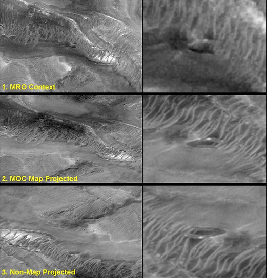
MIA011.1 Disc Shaped Feature - Comparison with 'map' and 'non-map' projected images - MGS 2000
Image credit: NASA/JPL/MSSS
Image sources: Original MSSS source links no longer work (images shown above). However, a PDS image source was found for the Non-map version (see last link below)
Non-map projected http://www.msss.com/moc_gallery/m13_m18/full_gif_non_map/M18/M1800558.gif
Map projected: http://www.msss.com/moc_gallery/m13_m18/full_gif_map/M18/M1800558.gif
PDS image source non-map projected: https://ida.wr.usgs.gov/fullres/divided/m18005/m1800558e.jpg
MIA011.2 Disc Shaped Feature - Comparison of MRO Context Camera (CTX) image with MOC images
Image credit (1): NASA/JPL/MSSS
Image pixel width: 6.32 m
Image source: (MRO Context CTX) http://viewer.mars.asu.edu/planetview/inst/ctx/G11_022486_1821_XN_02N020W#P=G11_022486_1821_XN_02N020W&T=2
(When viewing the full MRO CTX image, zoom in, and you will find this object at the very top right of the picture)
MIA011: Disc-Shaped Feature
IMAGE DETAILS
Mars Report Ref: MIA011
Report Date: July-August 2017
Research Status: Explained
Description: Disc-Shaped Feature
Approximate size: 150 m
Mission image/date: MGS August 2000
Image pixel width: 2.90 m
Location: Aram Chaos
Found by: Bret Colin Sheppard
Image credits: NASA/JPL/MSSS
Graphics/image editing: M. J. Craig
Image source: See image captions
OBSERVATIONS
The non-map projected image taken by MOC/MGS, gives the impression of a partial disc shape reflecting sunlight, which some have interpreted as being perched over a 'cliff'. However, as the image was taken from more or less directly overhead from orbit, the perceived viewing angle of this object is an illusion. The presence of sand dunes partially covering the object also implies the ground surface is relatively flat.
The map-projected image gives a clearer impression of the true shape of this feature where the specular reflections on the 'disc' follow a line which runs parallel with ridges of rock strata of a similar nature.
Due to MSSS recently handing their image database over to NASA/PDS, we have not yet been able to locate the original image links for the map and non-map versions which we show below in MIA011.1 and MR011.2.
POTENTIAL FOR AN ARTIFICIAL STRUCTURE
None. Feature satisfactorily explained by geology.
COMMON EXPLANATION
ACCEPTED - Illusion caused by incorrect image perspective.

MIA011.3 Visual Summary of Analysis of MIA011
Image credits: NASA/JPL/MSSS;
(processed by) Thomas Mikey Jensen
